Norway’s Ministry of Climate and Environment today awarded an international contract to KSAT who together with Planet, and Airbus provide universal access to high-resolution satellite monitoring of the tropics in order to support efforts to stop deforestation and save the world’s tropical forests. The contract is valued up to 405M NOK (~$43.5M, ~37M €). Through this program, the coalition of three geospatial organizations will bring new technologies and transparency to advance the mission of Norway’s International Climate and Forests Initiative (NICFI), which is to protect the world’s tropical forests and provide sustainable pathways to economic development for forest communities and countries.
“This will revolutionize global forest monitoring. Better insight into what is happening in the rainforests will enhance efforts to protect these priceless ecosystems”, says Sveinung Rotevatn, Norway's Minister of Climate and Environment.
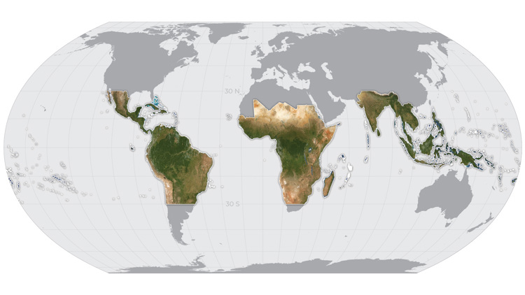
This unique and distinct partnership between the public and private sectors is the result of a comprehensive public procurement process led by Norway, with the ambition to utilize technology and data to help facilitate solutions towards the global challenge of tropical deforestation. Planet will provide high-resolution (sub-5m per pixel) Basemaps of the full tropics, covering over 64 developing countries, updated every month. These will be freely available for anyone to view and use through Norway’s technology partners, like Global Forest Watch.
This comprehensive offer is part of a team led by KSAT, who is the first point of contact and technical support for this Contract.
“We are pleased to bring together two industry-leading providers of optical satellite imagery in this disruptive initiative by NICFI and Norwegian Ministry of Climate and the Environment. By providing high resolution satellite images and making them publicly available, KSAT will contribute to a needed transparency with the goal to stop global deforestation”, said Rolf Skatteboe, President and CEO of KSAT. “This contract is important to KSAT and our joint effort aligns perfectly with our other global environmental monitoring and protection initiatives”.
Additionally, beginning in mid-October, anyone will be able to download the analysis-ready monthly Basemaps through Planet’s online satellite imagery platform, Planet Explorer, of these regions and for the purpose of supporting NICFI’s mission. KSAT, Planet, and Airbus will also work with select Norwegian partners to share the original image data, providing key global science and policy leaders with Planet’s daily imagery and Airbus’s unique high-resolution archive.
“Revolutionizing satellite data so we could see deforestation happening fast enough to stop it was one of the key reasons we founded Planet 10 years ago,” said Will Marshall, CEO and Co-Founder of Planet. “We are honored to partner with Norway, KSAT, and Airbus on this global crisis. Norway has taken a systematic approach to measuring natural capital in the key area of tropical forests, demonstrating the way to enable the transition to a sustainable economy”.
Aerospace industry pioneer, Airbus, is also on the team and is uniquely positioned to contribute to the project, with its huge archive of SPOT high resolution imagery, dating back to 2002-2015. Airbus’ SPOT satellites paved the way for the commercial use of satellite images by allowing coverage of large areas in record time for this resolution. This imagery archive represents a unique historical heritage at this scale, to monitor the evolution of our planet over time.
"Our satellites have been monitoring the Earth for over thirty-five years, supporting a wide range of environmental initiatives fighting deforestation. Our unique library of millions of square kilometers of imagery, built over decades, is a key asset in the fight against deforestation. Indeed our SPOT 5 archive will allow users to go back in time and understand the processes that led to the current situation, in order to help prevent them from happening again in the future”, said François Lombard, Head of Intelligence Business at Airbus Defence and Space.
One of the most compelling cases for these joint technical capabilities is monitoring and measuring forests by working with leaders in the international community. Satellite imagery is currently being utilized by the Food and Agriculture Organization of the United Nations (FAO) to monitor and protect the forests in Chile, Colombia, Democratic Republic of the Congo, Costa Rica, Ghana, Indonesia, Mexico and Mozambique. While Global Forest Watch is providing access to geospatial data to the public through the NICFI contract, it’s also working with the Forest Development Authority in Liberia, Amazon Conservation Association (ACA) and many more. It is clear that a global coalition is required to make a considerable impact on the 28 million hectares of forests being cut down every year while working to protect what is left.

Global map showing the extent of monthly Planet Basemaps to be provided through the partnership for tropical forest monitoring. © 2020, Planet Labs Inc. All Rights Reserved.
